Where We Be
 | |  | |  | |  | |  | |  | |  |


| Chamonix, France -- Map & Itinerary |
A map of the Chamonix Valley and its slew of
gondolas and lifts really helps with orienting
yourself here. It took us awhile to figure out
which gondolas were which, what hikes were
where, and so forth. See the link below for a
useful map of the entire Chamonix Valley.
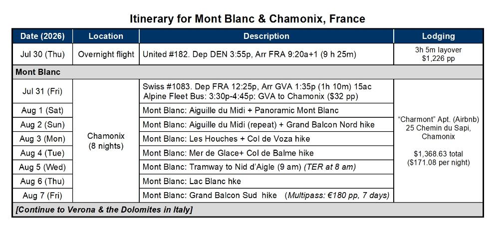
The itinerary for our one-week trip to Chamonix
is provided below. We say "one week" but it
was actually 8 days, as we wanted a full 7 days
to make the most of our 7-day Mont Blanc
Multipass. By all means get the Multipass!
We stayed at an Airbnb right in the heart of town
("Charmont Apt," 25 Chemin du Sapi) and would
highly recommend it or something similar, as it
puts you close to restaurants, cafes, bakeries,
gelato shops, grocery stores, etc. We were only
a 4-minute walk from the Aiguille du Midi base
station, which was especially helpful. We could
also walk to Montenvers Cog Railway, Chamonix
Sud bus station, the main train station, etc. The
pedestrian part of town was also close at hand.
Most guests staying in Chamonix get a free
Guest Card (Carte d’Hote) on arrival from their
hotel or Airbnb. It grants free bus and train
access up and down the entire Chamonix Valley.
Coupled with the Multipass, it essentially gives
you free transport everwhere you go. Sweet!
We recommend installing the free Chamonix-
Mont Blanc Valley App on your phone. It gives
you live updates on lifts, weather, webcams, etc.
gondolas and lifts really helps with orienting
yourself here. It took us awhile to figure out
which gondolas were which, what hikes were
where, and so forth. See the link below for a
useful map of the entire Chamonix Valley.
The itinerary for our one-week trip to Chamonix
is provided below. We say "one week" but it
was actually 8 days, as we wanted a full 7 days
to make the most of our 7-day Mont Blanc
Multipass. By all means get the Multipass!
We stayed at an Airbnb right in the heart of town
("Charmont Apt," 25 Chemin du Sapi) and would
highly recommend it or something similar, as it
puts you close to restaurants, cafes, bakeries,
gelato shops, grocery stores, etc. We were only
a 4-minute walk from the Aiguille du Midi base
station, which was especially helpful. We could
also walk to Montenvers Cog Railway, Chamonix
Sud bus station, the main train station, etc. The
pedestrian part of town was also close at hand.
Most guests staying in Chamonix get a free
Guest Card (Carte d’Hote) on arrival from their
hotel or Airbnb. It grants free bus and train
access up and down the entire Chamonix Valley.
Coupled with the Multipass, it essentially gives
you free transport everwhere you go. Sweet!
We recommend installing the free Chamonix-
Mont Blanc Valley App on your phone. It gives
you live updates on lifts, weather, webcams, etc.
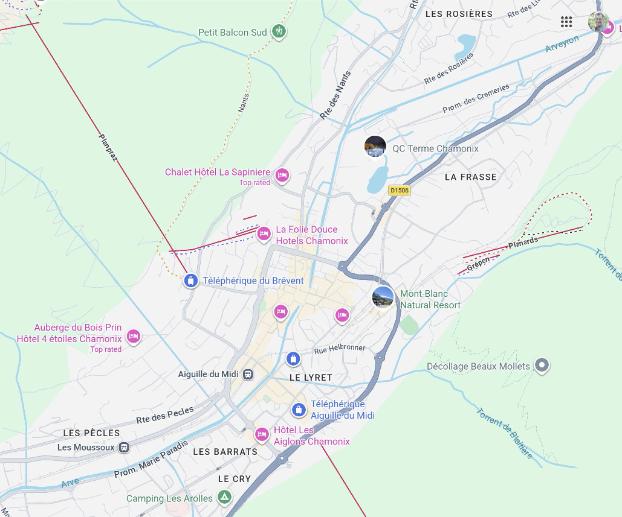
| The map above shows the center of Chamonix and two of the most important lifts -- Telepherique Aguille du Midi and Telepherique du Brevent. We stayed in an Airbnb close to the "Le Lyret" label. A more detailed map of Chamonix Valley is provided here |
| Map Data 2026 Google |